

![]()
![]()
![]()
|
|
More ........for an example of a typical feedback More ..........Notes on Running the School 1930-1939 Dr Raine - Obituary......................CLICK here More ..........These are memories of Vic Myers, who was a pupil at BCS but had left before the evacuation, but make excellent reading for any who either lived in Battersea or who are interested in life in Battersea pre-war. More............about the evacuation from Joy Millson nee Ling, daughter of the Headmaster More ....................A talk By Sean Creighton for the Latchmere Residents’ Association. More ....................Civilian Air Raid Casualties in Battersea and Wandsworth in the Second World War.
These are formatted in black and white, suggest best to print and read at leisure
PUBLICATION OF INTEREST Battersea Past. Patrick Loobey. (Historical Publications Ltd. 2002. ISBN 0948667761. £15.95)
Battersea's Past - a Review by Paul Askew To non-Londoners the name Battersea is synonymous with a famous dogs' home and a power station featured on the front of Pink Floyd's Animals album with a flying pig sailing through its chimneys. There is obviously however much more to the town and its rich history can now be gleaned from a new book Battersea Past, edited by local historian Patrick Loobey, with contributions from members of the Wandsworth Historical Society. Battersea was once a small village with a population centred on Battersea Square. With its "particularly good" soil for market gardening, it remained a predominantly rural agricultural parish, despite the construction of a bridge in 1771 and some industrialisation. The period between 1790 and 1914 has been called the most momentous in the history of Battersea, during which time the population swelled to 170,000 inhabitants, with the railways occupying much of the former market gardens. Factories and wharves covered the riverside after many chemical trades moved to the area because of the lack of pollution control and the good river and rail connections. To accommodate the increased population new homes had to be built and by 1887 building construction was the largest employer. New estates included the Crown at Battersea Park in 1846 to 1853 as well as Park Town and Shaftesbury Park. Incredibly, the old wooden Battersea bridge survived until 1883 when a new one was designed by Sir Joseph Bazalgate, chief engineer of the Metropolitan Board of Works, and was opened in 1890 - one of the narrowest in the capital. In 1858 a new south London park was created, and Battersea Park was chosen in 1951 for the "frivolous" side of the Festival of Britain and featured dancing, theatre, ballet, eating and drinking, with something called the Tree Walk a wooden platform at tree level among the favourite attractions. The park was chosen as the venue for the lighter side of the Festival of Britain, despite protests from residents in Prince of Wales Drive. The gardens proved so popular – 7.7million visitors in six months – they reopened the following year. Famous residents have included the political activist and Battersea MP John Burns, William Wilberforce who tirelessly spent 18 years trying to persuade Parliament to abolish the slave trade (he finally succeeded in 1807) John Walter, the founder of The Times, Punch editor Tom Taylor, whose play Our American Cousin was being watched by Abraham Lincoln when he was assassinated, novelist G K Chesterton and British and European light-heavyweight champion boxer Don Cockell, who famously challenged Rocky Marciano in 1955 for the world title, but was stopped in the ninth round. Since the Second World War a decline in industry has meant that almost all the riverside industries have been replaced by housing developments or commercial offices along the Thames, with many new retail developments such as those around Clapham Junction taking place during the 1980s and 90s. Loobey says: "Industry now in Battersea is probably at the same level as it was in the 17th century".
Godfrey Editions of Maps 100 & 101
These are extracts from the notes supplied with the Godfrey Editions of Maps 100 & 101. I did write to the publishers several months ago but received no reply so I hope they will not object.
The West London Extension Railway opened in March 1863, along with Clapham Junction Station. It was jointly owned by the London & South Western, London, Brighton & South Coast (one-sixth each), London & North Western and Great Western Railways (one-third each) and formed one of the few links between the northern and southern
networks in London.
The four branches at the south end of the WLER enabled an amazing array of services to be operated, and from Battersea Station Waterloo, Victoria, Ludgate Hill, Moorgate and London Bridge, as well as many suburban stations, could be reached.
Apart from the railways, horse trains had operated along Battersea Park, York and Falcon Roads since 1881-3, offering cheap fares for local workmen and their families such as Plough Road-Westminster for 2d.
Horse buses operated in 1895 from Clapham Junction via Albert Bridge to Knightsbridge, but were less frequent, more expensive, and started too late in the day for workmen.
Suburban development had, however, begun long before.
The new riverside factories led to small pockets of housing in and around the old village, including some that had become classic slums by the 1890s.
Little Europa Place was known as `Little Hell' because of its drunken and criminal population and other courts and alleys shown on the map were little better.
Most of the housing shown dates from after 1840, and no less than 40 separate building estates were involved in converting the fields and market gardens of Battersea into a sea of houses.
Good examples are the Falcon Grove area, developed by the architect William Willmer Pocock for a brickfield and housing between 1845 and 1882.
Evan Hare, a Putney solicitor, developed the Harefield estate on surplus railway land off Latchmere Road, wholly surrounded by the `Battersea Tangle'.
Among the largest developments were William Howey's Clapham Junction state and the Conservative Land Society's Plough Lane estate, both from 1863, which were to fill up the area north of the station within ten years.
North of Battersea Park Road was Colestown, named after E R Coles, a grid of streets inhabited by skilled artisans who formed the largest single element in Battersea in the 1890s,notably building and railway workers and those employed in local industries.
Falcon Park was developed by local builder-turned-developer Alfred Heaver after 1879, using many topical names from the Afghan War.
Heaver was also responsible for many other local estates, including Mossbury Road and the group of `-bury' roads off Wandsworth Bridge Road in Fulham.
Only around the edges of Battersea Park (1858) was there an attempt to provide more grandiose housing, including blocks of mansion flats along Prince of Wales Drive.
Apart from the park, the only open space left by 1894 was the Latchmere Allotments, a low-lying area which was finally covered by a pioneering local authority-housing scheme in 1903.
All these thousands of new houses were well supported by an infrastructure of shops and pubs, including survivors from the rural past such as the Princes Head, Raven, and Nags Head. In York Road was the Washington Music Hall, opened in 1886 with 600 seats. There were many churches, notably Christ Church, with its fine spire, built in 1847
well in advance of most local building, and chapels such as Battersea (Baptist) Chapel in York Road, rebuilt in 1870, which dates from 1676 when it lay in fields remote from the village.
The numerous three-decker Board Schools were almost the only `high-rise' buildings in 1894, soaring above the slate roofs of the two-storey terraces.
The railways brought jobs and people to the area, but were not entirely responsible for its surge in population.
The greatest expansion in this industry was between 1838 and 1869, yet the district's major growth came after these dates.
The population figures for Battersea are especially interesting, as it rose gradually from 6,887 in 1841 to 19,600 in 1861, and then rapidly to 54,016 in 1871, 107,262 in 1881 and 150,558 in 1891.
This map finds the area's population at its height.
John Wood
|
|
Send mail to
webmaster
with questions or comments about this web site. |
 The latest book on Battersea History was published last December 2002. It surveys Battersea’s history from early times, through the medieval, Stuart, and Georgian periods. It then examines the transformation from village to suburb through the Victorian period, It has sections on bridges, churches, open
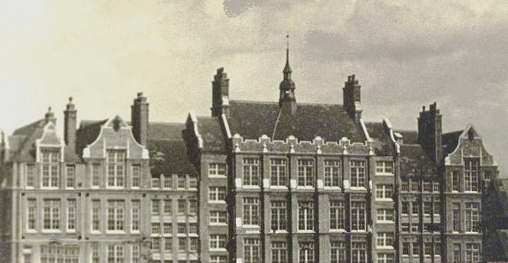
spaces, industry, local schools, leisure, town services, political life. It reviews some of the main developments in the 20th Century. Unfortunately it does not mention Battersea Central School. It is profusely illustrated.
The latest book on Battersea History was published last December 2002. It surveys Battersea’s history from early times, through the medieval, Stuart, and Georgian periods. It then examines the transformation from village to suburb through the Victorian period, It has sections on bridges, churches, open
spaces, industry, local schools, leisure, town services, political life. It reviews some of the main developments in the 20th Century. Unfortunately it does not mention Battersea Central School. It is profusely illustrated.